![](/images/other/stat-length.png)
![Excursión Senderismo Buenavista del Norte - Van Buenavista naar Teno Alto en naar Las Casas - Photo](https://media.geolcdn.com/t/1900/400/ext.pjpeg?maxdim=2&url=https%3A%2F%2Fservices.sitytrail.com%2FGeolivesWS%2FDownloadMedia.ashx%3FTrailID%3D871244%26Media%3Dfix__20171203152102.jpg)
Van Buenavista naar Teno Alto en naar Las Casas
karawatsj
Usuario
![Longitud](/images/other/stat-length.png)
![Altitud máxima](https://static1.geolcdn.com/siteimages/upload/files/1508320355ic_sort_altitude_max_24dp.png)
![Desnivel positivo](https://static1.geolcdn.com/siteimages/upload/files/1508320355ic_sort_den_pos_24dp.png)
![Km-Effort](/images/other/stat-length.png)
![Altitud mínima](https://static1.geolcdn.com/siteimages/upload/files/1508320355ic_sort_altitude_min_24dp.png)
![Desnivel negativo](https://static1.geolcdn.com/siteimages/upload/files/1508320355ic_sort_den_neg_24dp.png)
![Boucle](https://static1.geolcdn.com/siteimages/upload/files/16400158638029165_repeat_loop_refresh_sync_direction_icon.png)
![Senderismo](https://static1.geolcdn.com/sitytour/trail-icons/101.png)
3h40
Dificultad : Difícil
![Escanee este código QR para abrir la excursión en la aplicación SityTrail](https://capi.geolives.com/qq0zvz2zws4bq2lad0pu/sitytour/trails/871244/qr.png?size=200)
Aplicación GPS de excursión GRATIS
A propósito
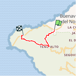
Ruta Senderismo de 8,9 km a descubrir en Canarias, Santa Cruz de Tenerife, Buenavista del Norte. Esta ruta ha sido propuesta por karawatsj.
Descripción
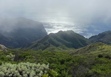
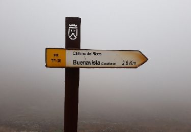
Wandeling begint op de rijweg TF-445 ca 2.5km voorbij Buenavista (weg afgesloten). Mooie wandeling met steile klim van ca 550m die na regen gevaarlijk kan zijn.
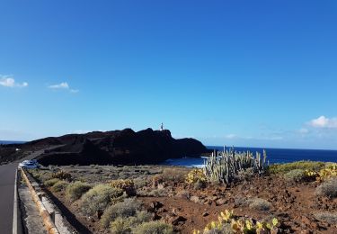
Goed gemarkeerd. Zodra je op het plateau bent kan je naar het uitzichtpunt Roque del Toscón (niet in deze gids). Vanaf Teno Alto gaat het richting de vuurtoren van Punta de Teno. Eens op de rijweg TF-445 nemen we de bus terug naar het beginpunt. Busverbindingen sporadisch (bevragen bij de busvervoermaatschappij Titsa of aan wachtpost aan de wagafsluiting.
Drank en eetgelegenheden in Teno Alto (bar Los Bailaderos)
Localización
Comentarios
Excursiones cerca
![Excursión Senderismo Buenavista del Norte - PR TF59 Mirador Cruz de Hilda -Masca - Photo](https://media.geolcdn.com/t/375/260/d47660bf-8be4-4598-8824-9c1776994929.jpeg&format=jpg&maxdim=2)
![Senderismo Senderismo](https://static1.geolcdn.com/sitytour/trail-icons/101.png)
Senderismo
![](/images/other/stat-length.png)
![](https://static1.geolcdn.com/siteimages/upload/files/16400158638029165_repeat_loop_refresh_sync_direction_icon.png)
![Excursión Senderismo Buenavista del Norte - Buenavista del Norte Teno Alto Punta del Teno - Photo](https://media.geolcdn.com/t/375/260/eac57375-6557-4997-8dd0-de41a6b22969.jpg&format=jpg&maxdim=2)
![Senderismo Senderismo](https://static1.geolcdn.com/sitytour/trail-icons/101.png)
Senderismo
![](/images/other/stat-length.png)
![](https://static1.geolcdn.com/siteimages/upload/files/16400158638029165_repeat_loop_refresh_sync_direction_icon.png)
![Excursión Senderismo Buenavista del Norte - Teno Alto - Photo](https://media.geolcdn.com/t/375/260/2f27afa0-c066-48db-babd-f8d4d2101f2d.jpeg&format=jpg&maxdim=2)
![Senderismo Senderismo](https://static1.geolcdn.com/sitytour/trail-icons/101.png)
Senderismo
![](/images/other/stat-length.png)
![](https://static1.geolcdn.com/siteimages/upload/files/16400158638029165_repeat_loop_refresh_sync_direction_icon.png)
![Excursión Ruta Buenavista del Norte - Punta de Teno- Teno Alto - Casablanca - Photo](https://media.geolcdn.com/t/375/260/8fc27228-d797-4dd9-847a-00b77a03d071.jpg&format=jpg&maxdim=2)
![Ruta Ruta](https://static1.geolcdn.com/sitytour/trail-icons/104.png)
Ruta
![](/images/other/stat-length.png)
![](https://static1.geolcdn.com/siteimages/upload/files/16400158638029165_repeat_loop_refresh_sync_direction_icon.png)
![Excursión Senderismo Buenavista del Norte - Camino del Risco - Photo](https://media.geolcdn.com/t/375/260/ext.jpg?maxdim=2&url=https%3A%2F%2Fservices.sitytrail.com%2FGeolivesWS%2FDownloadMedia.ashx%3FTrailID%3D853532%26Media%3Dfix__20171022162142.jpg)
![Senderismo Senderismo](https://static1.geolcdn.com/sitytour/trail-icons/101.png)
Senderismo
![](/images/other/stat-length.png)
![](https://static1.geolcdn.com/siteimages/upload/files/16400158638029165_repeat_loop_refresh_sync_direction_icon.png)
![Excursión Senderismo Buenavista del Norte - Boucle de la Palmar - Photo](https://media.geolcdn.com/t/375/260/ext.jpg?maxdim=2&url=https%3A%2F%2Fstatic1.geolcdn.com%2Fsiteimages%2Fupload%2Ffiles%2F1553511878bg_sport_marche.png)
![Senderismo Senderismo](https://static1.geolcdn.com/sitytour/trail-icons/101.png)
Senderismo
![](/images/other/stat-length.png)
![](https://static1.geolcdn.com/siteimages/upload/files/16400158638029165_repeat_loop_refresh_sync_direction_icon.png)
![Excursión Senderismo Buenavista del Norte - Canaries -Tenerife - Parc du Teno - jour 9 - Photo](https://media.geolcdn.com/t/375/260/ext.jpg?maxdim=2&url=https%3A%2F%2Fstatic1.geolcdn.com%2Fsiteimages%2Fupload%2Ffiles%2F1553511878bg_sport_marche.png)
![Senderismo Senderismo](https://static1.geolcdn.com/sitytour/trail-icons/101.png)
Senderismo
![](/images/other/stat-length.png)
![](https://static1.geolcdn.com/siteimages/upload/files/16400158638029165_repeat_loop_refresh_sync_direction_icon.png)
![Excursión Senderismo Buenavista del Norte - Tenerife Teno Alto n°24 - Photo](https://media.geolcdn.com/t/375/260/ext.jpg?maxdim=2&url=https%3A%2F%2Fstatic1.geolcdn.com%2Fsiteimages%2Fupload%2Ffiles%2F1553511878bg_sport_marche.png)
![Senderismo Senderismo](https://static1.geolcdn.com/sitytour/trail-icons/101.png)
Senderismo
![](/images/other/stat-length.png)
![](https://static1.geolcdn.com/siteimages/upload/files/16400158638029165_repeat_loop_refresh_sync_direction_icon.png)
![Excursión Senderismo Buenavista del Norte - portera Alta - Photo](https://media.geolcdn.com/t/375/260/ext.jpg?maxdim=2&url=https%3A%2F%2Fstatic1.geolcdn.com%2Fsiteimages%2Fupload%2Ffiles%2F1553511878bg_sport_marche.png)
![Senderismo Senderismo](https://static1.geolcdn.com/sitytour/trail-icons/101.png)
Senderismo
![](/images/other/stat-length.png)
![](https://static1.geolcdn.com/siteimages/upload/files/16400158638029165_repeat_loop_refresh_sync_direction_icon.png)